The Han River (Korean: 한강; RR: Hangang[e]) is a river located in the central region of the Korean Peninsula and is classified as a national first-class river in South Korea. The term "Miracle on the Han River," referring to South Korea's rapid economic growth, originates from this river.
The Han River has the highest flow rate of any river on the Korean Peninsula and also has the largest basin area. In terms of length, it is the fourth longest river on the entire peninsula and the second longest in South Korea after the Nakdong River.
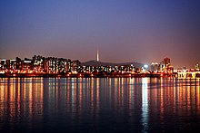
Seoul, the capital city of South Korea, is the only example of a major metropolis with such a wide river running through it; few large cities are divided by a massive river approximately 1.2 kilometers wide.[7]
The name Han River originates from the Korean word "Hangaram." In old Korean, "han" means "big" or "great," and "garam" refers to a river—so the name literally means "big river." Therefore, the Hanja character "Han" (漢) is merely a phonetic transcription. Until the early Three Kingdoms period, the Han River was called "Daesu" (帶水). It is recorded as "Arisu"[9] (阿利水) on the Gwanggaeto Stele—an ancient stone monument erected in 414 AD. In the kingdom of Baekje, it was called "Ungniha"[10] (郁利河). The Samguk Sagi ("History of the Three Kingdoms"), a historical text, records the river as "Hansanha" (漢山河) or "Bukdok" (北瀆). The name "Han River" began to be used around the time when Baekje started interacting with China's Eastern Jin Dynasty; from then on, it was called "Hansu" (漢水) or "Hangang" (漢江).[11][12]
Arisu (阿利水) is an archaic term used to refer to both the Han River and the Amnok River (Yalu River). Because of this historical significance, today it is also used as the brand name for tap water sourced from the Han River in Seoul. The term seems to derive from "ari," meaning "big" or "great," combined with "su" (水), which means "water." Some also speculate that "ari" itself means "water."[13][14][15]
The origin of the name "Arisu" dates back to the Three Kingdoms period and is first mentioned on the Gwanggaeto Stele.
According to records from other states during the Three Kingdoms period, in Baekje it was called "Ungniha" or "Hansu," while in Silla it was referred to as "Wangbongha" or "Hansanha."[16] During the Goryeo Dynasty, it was called "Yeolsu." Thus, among the old names of the Han River, "Arisu" is the one most familiar to modern Koreans.
At one time, the Standard Korean Language Dictionary listed "Arisu" as a dialectal term for "deception," but due to insufficient data and lack of clear evidence, it was deleted.[17]
There are records during the Goryeo period, that the Han River was also called Yeolsu (洌水),Sapyeongdo (沙坪島) and Sarijin.During the Joseon Dynasty, also as Gyeonggang (京江).[18][19]
There are non-korean articles that cite the han river as the 'Seoul river'[20]
Various Paleolithic and Neolithic artifacts have been discovered in the Han River basin, but the Amsa-dong Prehistoric Site in Gangdong-gu represents Neolithic culture. Artifacts such as pottery, stone tools, and spearheads, which provide insights into their dietary habits, have been unearthed. It is believed that these people engaged in intensive foraging activities in hills and low mountains, utilizing primitive fishing techniques like handline fishing or spear fishing from an early period, using tools such as spears or harpoons to catch fish.[22]
However, while handline and spear fishing were individual efforts with limited catch yields, net fishing allowed for large-scale catches through collective labor alongside foraging methods. Evidence of net fishing has been found in numerous archaeological sites. These communities accumulated surplus production through such collective activities, enhancing their adaptability to the environment and increasing their chances of survival. Consequently, their population grew, settlements expanded, and stable, sedentary lifestyles led to further cultural development. This progression laid the foundation for the emergence of ancient states in the Han River basin following the advanced cultures of the Bronze Age.[23]
Geographically encompassing most of central Korea, the Bronze Age in the Han River basin was influenced by the northeastern regions of the Korean Peninsula (Hamgyeongbuk-do and Hamgyeongnam-do) and the northwestern regions (Pyeongannam-do and Hwanghae-do). This led to the establishment of the Bronze Culture in the Han River basin. The cultures of these two regions developed uniquely through their own progress and blending, creating a distinctive Bronze Age culture in the Han River basin. Additionally, the Han River basin served as an intermediary region that facilitated the spread of culture to the southern regions of the Korean Peninsula. By this stage, agriculture had further advanced compared to the Neolithic period.[24]
Carbonized grains such as rice, barley, millet, and job's tears were excavated from habitation sites, indicating that mixed grain farming had become widespread across the Korean Peninsula. It is also inferred that rice farming had become quite common in both the northwestern regions and the southern areas. Rice farming in the Han River basin is closely related to the southward movement of residents from the Pangyi(팽이) Pottery culture in the northwestern regions. As these southern-moving Pangyi Pottery people interacted and blended with the local Minmuni-toki-in(민무늬토기인) communities, rice farming became widespread in the Han River basin and further extended to the southern regions.[25]
During the Three Kingdoms period, the fortunes of nations were closely tied to the gains and losses of the Han River basin. This was because the Han River, as a major river flowing through the central part of the peninsula, became the central stage of the Korean Peninsula. Additionally, it was considered important for military, economic, social, and diplomatic reasons. Consequently, this region became a primary target in the power struggles among the three kingdoms, and controlling the Han River basin provided a strong foundation for territorial expansion and national development. As historical records show, Goguryeo, Baekje, and Silla alternately ruled the Han River basin. Occupying the Han River basin led to national prosperity, while losing it resulted in decline.[26]
Baekje was founded in the basin of the Han River[27], and from the Three Kingdoms period onward, the zenith of each kingdom was determined by who controlled the middle and lower reaches of this river. Controlling the Han River was so crucial that it essentially defined a nation's golden age. Initially, Baekje held control, followed by Goguryeo, and later by Silla. As each kingdom rose to prominence, the other two would invariably form alliances to balance the power. This power dynamic continued throughout the entire Three Kingdoms period.
The importance of the Han River stemmed from its numerous advantages: the agricultural productivity of its basin, the securing of transportation routes through river navigation, and the establishment of maritime trade routes with China. It was the only region that could simultaneously connect major rivers flowing through the Korean Peninsula—such as the Taedong River, Geum River, Yeongsan River, and Nakdong River—and the shipping routes of the southwestern sea.[28]
After the unification of the Three Kingdoms, Silla designated the Hansanha (another name for the Han River) in the north as one of the nation's four great rivers, alongside the Hwangsanha (Nakdong River) leading to the South Sea, the Ungcheonha (Geum River) leading to the West Sea, and the Tojiha (Gokgangcheon in Heunghae-eup, Pohang) leading to the East Sea. These were collectively known as the "Four Waterways" (四瀆). The state held regular rituals (Jungsa, 中祀) for these rivers, underscoring their ideological importance.[29]
In the 21st year of King Munjong's reign, the importance of the Han River basin was recognized, and Yangju (present-day Seoul) was promoted to Namgyeong (Southern Capital), making it one of the three major strategic locations alongside Kaegyeong (Gaegyeong) and Seogyeong (Western Capital). Later, in September 1382 (8th year of King U), the capital was moved to Hanyang(Another name for present-day Seoul). However, due to political and social unrest, along with the prevalence of geomancy and the belief that the new capital was inauspicious, the capital was returned to Gaeseong the following February.[30]
During the reign of the last Goryeo monarch, Gongyang (1390), the capital was moved back again to Hanyang in September 1390. However, after the establishment of Hanyang, significant storms, thunder, lightning, and disasters struck the Nation,causing frequent misfortunes like people being swept away by the river,alongside bad omens such as Tigers killing men. As a result, in February 1391, the capital was moved back to Gaeseong, effectively ending the issue of relocating the capital (to Hanyang,or Seoul) within the Goryeo Dynasty.
The eventual relocation of the capital to Hanyang(Seoul) was achieved in 1394 when Yi Seong-gye founded the Joseon Dynasty.[31]
After ascending to the throne, Taejo Yi Seong-gye ordered the relocation of the capital to Hanyang on August 3, 1392, just 16 days after his coronation. This relocation was realized on October 25, 1394 (lunar calendar)[32]
After the capital relocation to modern day Seoul, the first time Seoul was the capital since any Korean nation since Bakjae's Wiryeseong, the Han river grew in importance alongside the city's new prestiege. The Korean peninsula,being a very mountainous region,has traditionally relied heavily on canal and river based water transport for everything from inter-province trade to taxes, which at the time were mostly payed in commodities.[33]
The capital's position along the Han River meant that the allocation and transportation of grains and various commodities from various provinces to the capital was with considerable more ease, allowing landlords residing in the capital to transport sharecropped grains from provincial(non-capital regions) farms to Hanyang via the river. Additionally, general goods within the capital were largely supplied by ships through the Han River. With the implementation of tax reforms and the introduction of the Daedong Law[34][35] in the late Joseon period, the Han River's importance increased further, facilitating the transportation of rice collected from regions like Honam and Chungcheong-do through waterborne routes. Thus, the Han River became a vital supply route for the state's grain reserves and national finances.[36]
As mentioned above,during the Joseon Dynasty, when river transport was central, the Han River served as a vital route through which goods from the Gyeonggi, Chungcheong, and Jeolla provinces flowed into Hanyang (the old name for Seoul). Additionally, when conducting rituals like praying for rain at famous mountains and great rivers, the Han River was always included. Even today, one can see people setting up ritual tables along the banks of the Han River during events like Jeongwol Daeboreum (the first full moon of the lunar year) and offering prayers.[37]
During the first few decades of South Korea's existence, the Han River became a byword for pollution, as burgeoning industry and an impoverished populace used it as a convenient spillway for industrial and urban refuse. Though it no longer plays a central role in commerce or transportation, it is a prime fixture in the life of the South Korean capital and in the last decade has become the focus of government sponsored environmental efforts to clean it up and transform it into an ecological jewel of the capital. During the 1988 Summer Olympics in Seoul, the Han River was the site of the Olympic rowing regatta.[38]
There have been fears, such as the 1986 Water Panic in South Korea, that North Korea could attack Seoul by releasing waters from upstream dams, creating floods downstream.[39] In July 2000, the US military admitted to dumping 20 gallons (75.7 liters) of diluted formaldehyde in the sewer system connected to the river. As the river serves as a drinking source for some 12 million South Koreans, some South Koreans launched large protests and accused the US military of ignoring South Korea's environmental regulations. Activists lobbed toy rockets—filled with water from the river—into the main US Army base. The political party Green Party Korea had earlier accused the US of dumping nearly 60 gallons of the toxic chemical into the river, and said that "... if people are exposed to the chemical for a long period of time, it could cause lung cancer [and when] dissolved into water, it could kill fish and other aquatic creatures."[40][41] The events inspired Bong Joon-ho's acclaimed 2006 film The Host.
In 2012 the 18-kilometer Ara Canal was completed,[42] linking the Han River near Gimpo in Seoul to Incheon. It can accommodate both large container and passenger vessels.
On November 4, 2018, a 20-member team consisting of 10 people from North Korea and 10 people from South Korea began a joint inter-Korean survey which will lead to the development a Joint Utilization Zone along the Han River's estuary.[43][44] The zone will allow civilians to access the estuary for tourism, ecological protection and the collection of construction aggregate under the protection of militaries from both sides of the Korean border.[43][44] On November 5, 2018, the councils of South Korea's Gangwon and Gyeonggi provinces, which border the DMZ, signed a “peace working agreement” at Dorasan Station in Paju, giving local approval to the Joint Utilization Zone.[45]
The Han River has an exceptionally high flow variability coefficient and is known for its excessively narrow basin. As a result, during heavy rains—such as monsoons or torrential downpours—the Jamsu Bridge becomes submerged, and even the expansive riverbanks and Hangang Park are entirely flooded. This illustrates the significant fluctuations in the river's water volume. Conversely, during the dry winter season, the river's width decreases considerably.
An environmental advantage of the Han River is its role in reducing and mitigating the urban heat island effect. When the river flows normally, the kinetic energy of the water collides with the air to create wind, which helps circulate the surrounding air.
Even today, several places in Seoul bear names derived from former Boat crossings, such as Gwangjin (Gwangnaru), Mapo, Sangam Naru, Ttukseom Naru, Gongam Naru, Songpa Naru, Hangangjin, Yanghwajin (Yanghwa Naru), Sambat Naru, Dongjak Naru, Seogang Naru, Noryangjin (Nodeul Naru), and Yeongdeungpo. These names reflect the Han River's wide expanse and its suitability for river transport, highlighting its geographical features and advantages. Among them, Noryangjin (Nodeul Naru) was renowned as a key transportation hub managing both passenger and grain transport on the Han River. Consequently, grain warehouses and fishing ports were established there. Even in the 2020s, Noryangjin is home to the Noryangjin Fisheries Wholesale Market.
The section of the Han River that flows through Seoul maintains a water level above a certain point due to the Singok Submerged Weir installed in Gimpo City. This maintained water level is referred to as the "low water level" (jeosu-wi), and the filled section is called the "low water channel" (jeosu-ro). This setup serves not only aesthetic purposes but also facilitates the operation of tour boats. Following the Han River Comprehensive Development Project, extensive aggregate extraction deeply excavated the riverbed, providing sufficient depth for tour boats even without the submerged weir. However, to accommodate docking and other activities, the submerged weir remains necessary unless additional dredging is performed near the docks.[46]
The total length of the Han River is approximately 514 kilometres (319 mi).[49][4] Although it is not a long river, the lower Han River is remarkably broad. Within Seoul city limits, the river is more than 1 kilometre (0.62 mi) wide. Prior to the construction of several major dams, the river was known for its huge coefficient of river regime (ratio between the maximum and minimum amount of flow) of 1:39. (For comparison, The Thames and the Rhine have coefficients of 1:8 and 1:18, respectively.)[50]
Tributaries are listed in order from the mouth of the Han River to the source. Subtributaries are listed accordingly.
Also
The river serves as a water source for over 12 million South Koreans. In July 2000, the United States military admitted to having dumped formaldehyde in the sewer system connected to the river, which caused protests.[51]
The lower stretches of the Han River are lined with pedestrian walkways, bicycle paths, public parks and restaurants, particularly in Seoul. In a 2011 survey conducted by Seoul Development Institute of 800 residents and 103 urban planning and architectural experts, 51% of residents and 69% of experts voted the river the second most scenic location in the city, following Mount Namsan in the top spot.[53]
Records of the Han river from the three kingdoms period to the Joseon Dynasty can be found in records such as 삼국사기·동국여지승람·연려실기술·세종실록지리지·고려사지리지·팔도지리지·택리지
^한강을 부르는 명칭은 시대와 지역에 따라 매우 다양했다. 중국의 한(漢)·위(魏)나라에서는 ‘대수(帶水)’라 하였으며 후한(後漢, 25년~220년)의 역사가 반고가 저술한 역사서, 『한서(漢書)』 지리지에는 대수(帶水)로 표기되어 있다. ‘대수’란, 한강의 모습이 한반도의 허리에 띠를 두른 것과 같음을 표현한 것이다. https://hangang.seoul.go.kr/www/contents/762.do?mid=561
^Arisu is a term formed by combining the native Korean word "ari," meaning "big," with the Sino-Korean character "su" (水), meaning "water." During the Goguryeo period, Arisu was used to refer to the Han River. This term is recorded on the Gwanggaeto Stele, specifically in the conquest accounts of the 6th year, the year Byeongshin (丙申年), detailing Goguryeo's attack on Baekje.
^In the "Samguk Sagi" (History of the Three Kingdoms), Baekje Annals Volume 3, in the account from early September of the 21st year of King Gaero, there is a record similar to that on the Gwanggaeto Stele. Here, the Han River is referred to as "Ungniha" (郁里河). Professor Lee Byung-do annotated that this is the same as "Arisu" mentioned in the Gwanggaeto Stele, and that it indeed refers to the Han River. (From Lee Byung-do's annotated translation,(이병도역주, 「국영삼국사기」)
^광개토왕릉비(廣開土王陵碑)에는 아리수(阿利水)라고 표기되어 있는데, 여기서 ‘아리’, 즉 ‘알’은 고대에 크다거나 신성하다는 의미로 쓰였다. 『삼국사기(三國史記)』의 백제건국설화에는 한수(寒水), 『삼국사기지리지(三國史記地理志)』에는 ‘한산하(漢山河)’ 또는 ‘북독(北瀆)’이라 표기하였으며, 백제에서는 욱리하(郁里河)라고 부르기도 하다.https://hangang.seoul.go.kr/www/contents/762.do?mid=561
^"Samguk Sagi" (History of the Three Kingdoms), Volume 3, "Annals of Silla," Book 3, Entry for the 11th Year of King Jabi Maripgan
^국립 국어연구원에서 펴낸 표준 국어 대사(1999)에, ‘아리수'는「한강의 옛 이름」으로 기재되어 있고「속임수의 잘못」이라고 밝혀 놓았음. 이는 ‘아리수'가「한강의 옛이름」이란 것을 명시한 것이며, 이를 ‘속임수'로 쓰는 것은 잘못이라는 뜻임.
이전에 발간된 일부 국어 사전에서 ‘아리수'를 「‘속임수'의 방언」으로 기재하고 있으나 어느 지역의 방언인지 확인할 수 없는 상태로 옛날 일부 지방에서 쓰이다가 사라진 말로 추정됨.[2004.9.17] Korean Language Society
^한강유역에서 구석기, 신석기시대 유물이 각지에서 발견되고 있으나 강동구 암사동 선사유적지는 신석기 문화를 대표하는 것이며 그들의 식생활을 엿볼 수 있는 자료로서 토기, 석기 또는 골각기 등이 발견되고 있다. 이들은 구릉이나 야산에서 집중적인 채집활동을 벌였을 것으로 생각되며 원초적인 어로기법인 낚시어법이나 자돌어법이 일찍부터 성행하여 창 또는 작살을 이용하여 물고기를 찔려 잡기도 하였을 것이다. https://hangang.seoul.go.kr/www/contents/818.do?mid=563
^그러나 이러한 자돌어법, 낚시어법이 개인적인 단독작업으로서 어획량이 많지 않은데 비해 어망을 이용한 고기잡이는 채집어법과 더불어 집단적 공동작업을 통하여 대량어획을 가능하게 하는 어로기법인데 그러한 증거로서 어망추가 여러 유적에서 다수 발견되고 있다. 그들은 바로 이러한 공동작업에 의한 대량생산을 통하여 잉여생산물을 축척하여 나갔고 그것은 한편으로는 환경에의 적응도를 높여 생존가능을 증대시켰으며, 그에 따라 인구가 증가되고 취락이 팽창하였으며 안정된 정착생활을 통하여 문화가 더욱 발전하게 되었고 이후 청동기시대의 발달된 문화를 거쳐 한강유역에서 고대국가가 발달하게 되는 기반을 마련하였다고 볼 수 있다. https://hangang.seoul.go.kr/www/contents/818.do?mid=563
^지리적으로 한반도 중앙의 대부분을 포함하고 있는 한강유역의 청동기시대는 한반도 동북지방(함경 남북도)의 민무늬토기, 구멍무늬토기, 붉은간토기문화, 서북지방(평안남도, 황해도)의 팽이토기문화의 영향을 받아 민무늬토기문화 및 청동기문화가 성립되었으며 이들 양지역의 문화는 자체적인 발전과 혼합을 통해 한강유역의 독특한 청동기문화를 이룩하고 한편으로는 한반도 남부지방으로 문화를 전파시켜 주는 중간 매개지역의 역할도 담당하였다. 한반도에서는 민무늬토기 시대에 이르러 신석기이래의 농경이 더욱 발전된 것으로 보여진다. https://hangang.seoul.go.kr/www/contents/818.do?mid=563
^유적지 움집터에서 탄화된 쌀, 보리, 수수, 기장이 출토된 것으로 미루어 잡곡농사가 한반도 전역에 일반화되었음은 물론, 벼농사도 서북지방과 남한지역에 상당히 일반화되었을 것이라는 추측을 할 수 있다. 한강유역의 벼농사는 서북지방 팽이토기 주민의 남하와 깊은 관계를 가지고 있으며 이들 남하한 팽이토기인들이 재래의 동북계 민무늬토기인과 접촉 융화하면서 한강유역, 나아가서는 남한지역에까지 벼농사가 일반화 된 것으로 생각된다.https://hangang.seoul.go.kr/www/contents/818.do?mid=563
^삼국시대에 접어들면서 한강유역의 득실이 나라의 흥망성쇠와 지대한 관계를 갖고 있었다. 그 이유는 한강유역이 반도의 중앙부를 축으로 관류하는 큰 강인 만큼 한반도의 중심무대지가 되었기 때문이다. 또한 군사, 경제, 사회, 외교적 제조건을 구비하고 있었기 때문으로 간주된다. 따라서 이 지역이 삼국쟁패의 주요 과녁이 되었고 한강유역을 점유한 국가는 영토적 확장과 더불어 국가발전의 강력한 터전을 마련한 결과가 되었다. 결국 고구려, 백제, 신라가 한강유역을 번갈아 지배했던 사실을 전 역사과정에서 알 수 있듯이 한강유역을 점유하면 나라가 번영하였고 상실하면 쇠퇴하였다. https://hangang.seoul.go.kr/www/contents/818.do?mid=563
^전근대사회에 있어서 국가재정의 운용을 위한 수입은 거의 농업생산물에 의지하고 있었다. 농업경제가 사회의 기반을 이루고 상태에서는 현물을 조세로 수취하였다. 따라서 조정에서는 세곡의 운송에 큰 관심을 가지게 마련이었다. 그러나 도로망을 포함하여 육상교통 수단이 별로 발달하지 못했던 까닭에 조세는 주로 대량수송이 용이한 조운을 통해 운송되었다. 그러므로 도읍지로서의 위치는 수륙의 교통이 편리한 곳에 있어야 함은 필수적이었다.
따라서 이러한 지리적 위치 등을 고려하여 선택한 한강을 끼고 있는 한양은 천도때부터 조운의 발전은 필연적인 것이라 할 수 있다. 전국의 세곡이 조운을 통하여 한강에 모였고, 한양에 거주하는 지주층이 지방농장에서 거두어 들인 소작도 대부분 선박으로 이곳에 운반되었다. 도성내 일반 생활품도 그 양이 많은 것은 대부분은 선박으로 한강을 통하여 공급되었다. 그리고 조선후기에 이르러 세제개혁과 아울러 대동법이 실시됨에 따라 한강은 더욱 중요성을 더하게 되었으며, 호남을 비롯하여 충청도 등지에서 수납되는 대동미는 조운선을 통하여 한강으로 수송되었다. 따라서 한강은 백관의 녹봉과 국가재원을 충당시켜 보급로가 되었다.https://hangang.seoul.go.kr/www/contents/818.do?mid=563