Neelin
Appearance
This article needs additional citations for verification. (September 2016) |
Neelin | |
|---|---|
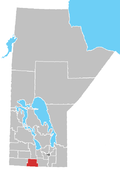
Location of Neelin in Manitoba | |
| Coordinates: 49°13′45″N 99°21′03″W / 49.22917°N 99.35083°W | |
| Country | |
| Province | |
| Region | Pembina Valley |
| Census Division | No. 4 |
| Government | |
| • Governing Body | RM of Roblin, Prairie Lakes, Argyle |
| • MP | Larry Maguire |
| • MLA | Grant Jackson |
| Elevation | 436 m (1,430 ft) |
| Area code | 204 |
| GNBC Code | GBACH |
Neelin is a small community in the Canadian province of Manitoba. It is located on Manitoba Provincial Highway 5 in the Rural Municipality of Argyle, about 29 km east of Killarney, or about 200 km southwest of Winnipeg.
The Roseberry school district was established in 1885, leading to the construction of a one-room schoolhouse in 1904. The school served as a K–12 school until 1960, when high school students began to bus to either Baldur, Killarney or Cartwright. Roseberry, now known as Neelin school, continued until 1968, when it was closed. The building has since been demolished.
Neelin was also home to a Manitoba Pool elevator. The elevator stood on the CPR railroad tracks until its closure in 1978.
See also
[edit]References
[edit]
- ^ Goldsborough, Gordon. "Historic Sites of Manitoba: Neelin Cemetery (Neelin, RM of Argyle)". www.mhs.mb.ca. Retrieved August 8, 2016.


